• Tentang UGM
  • Portal Akademik
  • Pusat TI
  • Perpustakaan
  • Penelitian
  • Informasi Publik
  • Bahasa Indonesia
    • Bahasa Indonesia
    • English
Universitas Gadjah Mada Universitas Gadjah Mada
Fakultas Geografi
  • Profil
    • Sejarah
    • Visi, Misi dan Tujuan
    • Sambutan Dekan
    • Manajemen
      • Pimpinan Fakultas
      • Senat Fakultas
      • Pengelola Departemen
      • Pengelola Program Studi
    • Civitas Akademika
      • Dosen
      • Staf Kependidikan
  • Pendidikan
    • Program Sarjana
      • Geografi Lingkungan
      • Kartografi dan Penginderaan Jauh
      • Pembangunan Wilayah
      • International Undergraduate Program
    • Program Pascasarjana
      • Program Studi Magister Geografi
      • Program Studi Magister Geografi Minat Pembangunan Wilayah
      • Program Studi Magister Geografi Minat MPPDAS
      • Program Studi Magister Penginderaan Jauh
      • Program Studi Doktor Geografi
    • Admisi
      • Program Sarjana
      • Program Pascasarjana
      • Program Fast Track S1 – S2
      • MATRIKULASI D4 ke S1
    • Akreditasi
  • Akademik & Kemahasiswaan
    • Peraturan Akademik
      • Panduan Akademik
      • Kode Etik Mahasiswa Geografi
      • Tata perilaku Mahasiswa UGM
    • Layanan Kemahasiswaan
    • Layanan Akademik
    • Kalender Akademik
    • Seputar Magang
    • Beasiswa
    • Organisasi Kemahasiswaan
    • Ikatan Profesi Dan Lembaga-Lembaga Lain
  • P2M
    • Penelitian & Pengabdian Masyarakat
    • Tracer Study
  • Kerja sama
    • Dalam Negeri
    • Luar Negeri
    • Alumni
  • Fasilitas
    • Akademik
    • Student Wellbeing
    • Peminjaman Ruang
    • Ruang Kebugaran
  • Beranda
  • Publikasi
Arsip:

Publikasi

The Economic and Poverty Impact of Migration: is Repeated Migration Better Than One-Way Migration?

Publikasi Rabu, 21 Mei 2025

Nanang Widaryoko | Sukamdi | Agus Joko Pitoyo
Cogent Social Sciences 2025, Vol. 11, no. 1, 2495858

Abstract

Scholarly discourse on migration has traditionally examined the welfare implications for migrants and non-migrants, yielding diverse perspectives. However, the conventional portrayal of migration as a one-way, overlooks the dynamic nature of contemporary migration, rendering discussions on the impact of migration less comprehensive. This study fills the gap by investigating the economic and poverty impacts of repeated migration versus one-way migration in Indonesia. Using panel data from the Indonesian Family Life Survey (IFLS) from 1993 to 2014, we apply a multinomial endogenous switching regression model and Propensity Score Matching (PSM) to analyze migration outcomes across different migration trajectories. Our findings reveal that migrants who engage in onward migration generally experience higher economic welfare than one-way migrants. Among one-way migrants, those who migrated as children have the highest economic outcomes, while one-way migration in adulthood tends to be less beneficial. In terms of poverty impact, migrants who moved as children have the most significant effect on poverty reduction, followed by onward migrants, while migrants who move as adults do not significantly reduce poverty. These results underscore the importance of considering migrant quality, migration duration, and migration trajectory in achieving migration outcomes. In addition, these findings show the importance of classifying migration as not only one way but also repeated migration. read more

Capturing The Dynamics of Aboveground Carbon Stock in Intertidal Seagrass Meadows Using Sentinel-2 Time-Series Imagery

Publikasi Rabu, 14 Mei 2025

Pramaditya Wicaksono | Amanda Maishella | Ramadhan

Remote Sensing Applications: Society and Environment, Volume 38, April 2025, 101552

Abstract

One of the challenges associated with the monitoring of seagrass meadows is the seasonal variability in percent cover, which is closely linked to the aboveground biomass carbon stock (AGC). To gain a comprehensive understanding of seagrass dynamics, it is essential to obtain spatial and temporal information on seagrass AGC. The most effective approach for mapping the dynamics of seagrass AGC is remote sensing; however, limited robustness of the mapping model limits their applicability across different locations. To address this issue, we developed a robust model for mapping seagrass AGC, with the objective of capturing the dynamics of seagrass AGC in intertidal seagrass meadows. Using seagrass field data and assuming that pure seagrass and sand pixels have 100 % and 0 % seagrass cover, respectively, we trained stepwise, machine learning (random forest, support vector machine, and multivariate adaptive regression spline), and deep learning (dense neural network) regression models to convert Sentinel-2 reflectance into seagrass AGC. The accuracy of the models was evaluated at multiple sites with available field data, and the results demonstrated an RMSE ranging from 6.28 to 13.97 g C m−2 and a correlation coefficient between 0.69 and 0.83. Overall, the SVM regression model exhibited the highest accuracy. The SVM model was subsequently applied to 13 seagrass sites across Indonesia over a 36-month period, revealing consistent and recurring monthly and bimonthly AGC patterns. The majority of seagrass meadows exhibited their highest AGC during the May–June period and their lowest during the September–October period. This study also represents the first time-series mapping of seagrass AGC in Indonesia on a monthly and bimonthly basis, marking a significant advancement in understanding seagrass’s potential as a blue carbon sink. Additionally, to achieve more accurate assessments of seagrass changes, it is crucial to account for the monthly and seasonal dynamics in seagrass growth patterns. read more

The Macroeconomic Impact of Population Aging in Indonesia: Do Older Adults Matter?

Publikasi Jumat, 9 Mei 2025

Titik Munawaroh | Sukamdi | Abdur Rofi | Umi Listyaningsih

Asian Economic and Financial Review Vol. 15 No. 3 (2025)

Abstract

Indonesia, the fourth most populous country globally, is approaching an aging population and is considered unprepared for its consequences. In this context, the effect of population aging on economic growth is a widely debated topic. Previous research has shown different perspectives, stating that population aging positively and negatively influences economic growth, while other analyses report an ambiguous relationship. Therefore, this research aimed to explore the phenomenon of population aging and its economic implications by using regional macro data at the district or city level from the official 2020 BPS-Statistics Indonesia publication. Using a linear regression method, the results showed that population aging, measured by the OADR (Old Age Dependency Ratio), both traditional and modified, possesses a substantial negative influence on economic growth. However, older workers contribute positively since an increase in labor force participation could mitigate the negative consequences of population aging. Increased inclusion of older adults in economic activities is also a potential strategy for mitigating the impact. The model suggests that this method reduces economic burdens associated with an aging population. However, further research is needed to determine the most effective methods to increase the inclusion of older adults in the workforce while safeguarding basic rights in terms of health and well-being. read more

Multitemporal Satellite Images For Monitoring The Volcanic Activities and Geothermal Potential of Ternate Island’s Gamalama Volcano, Indonesia’s densest Active Volcanic Island

Publikasi Kamis, 8 Mei 2025

Bondan Galih Dewanto | Danang Sri Hadmoko | Nurul Fitrah Ramadhani | Admiral Musa Julius

Remote Sensing Applications: Society and Environment Volume 38, April 2025, 101555

Abstract

Throughout history, Ternate, a diminutive volcanic island located in the North Maluku Province of Indonesia, has functioned as a significant center of the nation’s social and economic activity. The Gamalama Volcano constituted a significant element of Ternate Island’s topography, and its eruption resulted in substantial disruption. The aims of this current contribution are: to monitor the historical activities of the Gamalama volcano and understanding the geothermal potential to support the energy needs in Ternate Island. The multi-temporal analysis was conducted to monitor the activity of Gamalama Volcano, utilizing satellite imagery spanning a period of 50 years. The imagery sources included Landsat 1, Landsat 4, Landsat 5, Landsat 7, ASTER, and Landsat 8. The present study employed the single-channel algorithm to derive the land surface temperature (LST). The band combination and ratio were utilized to infer the geological context and geothermal capacity of the Gamalama Volcano. The analysis of normalized differential vegetation index (NDVI) utilized in the calculation of LST has revealed that vegetation growth has occurred subsequent to certain volcanic eruptions. As per the LST data, the average temperature of the surface within the crater escalated to 38.472 °C during the eruption of 1997, thereby establishing it as the maximum temperature recorded in the past half-century. The volcanic activity of Gamalama Volcano was elucidated through the utilization of the LST technique, which has the capacity to cover various temporal intervals. The congruence between the LST data derived from Landsat and ASTER data substantiates the dependability of the LST methodology. The geothermal potential of approximately 16 °C has been observed in the crater and sand region of the volcano, along with the identification of supplementary hot spots in the north-eastern and western regions of the volcano’s primary structure. The utilization of Landsat 8 band combinations and band ratios has substantiated the presence of an area exhibiting elevated geothermal potential within the andesite and basaltic andesite geological formations. The practicality of utilizing multi-source optical satellites for monitoring volcanic activity has been exemplified by the multiple eruptions that have occurred at Gamalama Volcano. Furthermore, this technology could potentially be employed for conducting exploratory research into the geothermal potential of the region.
read more

Karst Rocky Desertification Delineation and Estimation of Potential Soil Loss in Tropical Karst Cockpits

Publikasi Kamis, 8 Mei 2025

Rakhmat Dwi Putra | Tjahyo Nugroho Adji | Eko Haryono

Kuwait Journal of Science, Volume 52, Issue 3, July 2025, 100422

Abstract

Tropical cockpit karst, characterized by hilly topography, steep slopes, and thin soil layers, is highly susceptible to land degradation in the form of karst rocky desertification (KRD). KRD occurs due to acute soil erosion in karst environments, leading to the exposure of bedrock. This study aims to provide a comprehensive analysis of KRD, accurately assess soil erosion rates in cockpit karst landscapes, and identify the contributing factors. The research was conducted within the Seropan underground river catchment area in the Gunungsewu Karst region. KRD was identified using an image transformation approach employing the Karst Rocky Desertification Index (KRDI). Soil loss estimation was performed using the updated Revised Universal Soil Loss Equation (RUSLE) method, incorporating the KRD factor to enhance its applicability in karst environments. The results demonstrate that KRDI is highly effective in identifying KRD. Approximately 40 % of the study area exhibits moderate to severe KRD levels, predominantly found on the slopes of conical hills, where the primary driving factors are deforestation, land clearing for dryland agriculture, and abandonment of agricultural land. The estimated total soil loss in the study area is 4975.01 tons per year, with the highest contribution occurring at the intense soil loss level. The intense to extremely intense-severe soil loss levels are correlated with the steep slopes of conical hills, highlighting the significant role of topography in soil degradation within tropical karst environments.

View Publication
read more

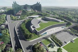
Metaverse, Digital Twins, dan Konsep Smart Sustainable Urban Development untuk IKN

PublikasiRilisSustainable Development Goals Senin, 13 Januari 2025

Kemajuan ilmu pengetahuan dan teknologi mampu mengubah batas-batas pengetahuan. Kemajuan tersebut dapat memunculkan teknologi disruptif yang berdampak besar pada masyarakat perkotaan, seperti metaverse, digital twins, dan berbagai konsep menarik lainnya. 

Penelitian terbaru yang dilakukan oleh Prof. Dr. Rini Rachmawati, S.Si., M.T., dosen Fakultasi Geografi Universitas Gadjah Mada (UGM) bersama timnya berjudul “Metaverse, Digital Twins, and Smart Sustainable Urban Development Concepts for Nusantara Capital City, Indonesia” ini menekankan bagaimana konsep-konsep seperti kembaran digital, metaverse, dan pembangunan perkotaan berkelanjutan dapat berkontribusi pada pengembangan Nusantara dan menjadi salah satu terobosan inovasi dalam pembangunan ibu kota.   read more

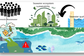
Pencemaran Laut Pada Ekosistem Pulau Kecil dan Dampak Limbah Domestik di Pulau Bungin

PublikasiRilisSustainable Development Goals Selasa, 7 Januari 2025

Pulau-pulau kecil dengan kepadatan penduduk yang tinggi sering kali menghadapi masalah lingkungan yang cukup serius, salah satunya adalah pencemaran air akibat limbah domestik. Ditambah lagi jika wilayah tersebut tidak memiliki pengelolaan air limbah yang memadai, pencemaran dari sumber domestik dapat mempengaruhi kesehatan ekosistem laut.

Fenomena inilah yang menjadi latar belakang Dr. Rika Harini, S.Si., MP., dosen Fakultas Geografi Universitas Gadjah Mada (UGM), bersama tim untuk memilih Pulau Bungin, salah satu pulau dengan kepadatan penduduk tertinggi yang terletak di Kabupaten Sumbawa, Nusa Tenggara Barat, sebagai fokus studi pada penelitian ini.  read more

The 1257 CE cataclysmic eruption of Samalas volcano (Indonesia) revealed by indigenous written sources: Forgotten kingdoms, emergency response, and societal recovery

Publikasi Jumat, 20 Januari 2023

Muhammad Ngainul Malawani | Franck Lavigne | Wayan Jarrah Sastrawan | Jamaluddin | Ahamad Sirulhaq | Danang Sri Hadmoko

Journal of Volcanology and Geothermal Research, Volume 432, December 2022, 107688

Abstract

Historical and archaeological findings have revealed that many human civilizations have been strongly affected by natural hazards, such as volcanic eruptions. An issue that still lacks attention is the response of ancient populations following eruptions as well as their resilience strategies. Three written sources from Lombok, Indonesia, provide descriptions of the ancient landscape of Lombok and the population’s response to the Samalas volcano eruption in 1257 CE. The sources depict the conditions of Lombok and the surrounding areas during the pre-, onset-, and post-eruption phases of a catastrophic volcanic eruption with a volcanic explosivity index 7. Various responses of the inhabitants to the eruption are described in the sources, such as fleeing to the hills, avoiding hazards, and escaping to neighboring villages or islands. Several geographic features and toponyms are mentioned, allowing us to reconstruct the evacuation process during the crisis period. The sources also describe recovery strategies in the post-eruption period, including governance strategies, the rebuilding of cities and villages, and agriculture. The historical record suggests that Lombok may have taken up to a century to recover from the eruption and that new kingdoms and principalities became established by the fourteenth century. Disaster management related to the eruption is described in the texts from Lombok, but not in older written sources from Indonesia. read more

Spatial Multi-Criterion Analysis (SMCA) to Determine the Suitability of Green Open Space (GOS) at Kalurahan Wonokromo, Special Region of Yogyakarta

Publikasi Kamis, 19 Januari 2023

 Joni Purwohandoyo | Hilary Reinhart | Erlis Saputra | Andri Kurniawan | Rini Rachmawati | Dyah Widiyastuti | Arry Retnowati | Mohammad Isnaini Sadali | Rizki Adriadi Ghiffari

International Review for Spatial Planning and Sustainable Development, Volume 11, 2023, Issue 1, Pages 158-175

Abstract

MRapid urbanization and growth in the Kalurahan Wonokromo, situated in the peri-urban area of Yogyakarta City causes the loss of children’s playgrounds while the number of children is increasing. Preserving the remaining space for Green Open Space (GOS) is crucial. Amid the space limit, choosing the right location is one of the keys to ensuring the space functions optimally. We employ the Spatial Multi-Criteria Analysis (SMCA) in selecting several location candidates for the development of GOS using 9 criteria of tree cover, existing open green space, ricefield, social facilities, accessibility, distance to school, presence of small shop, children density, and the riverbank. The SMCA analysis is powered by Analytical Hierarchical Process using expert judgment combined with GIS analysis to yield the weight priority and score for each criterion. As the result, the score for each criterion is 0.3218 for existing open green space, 0.1616 for social facilities 0.1446 for small shops, 0.1265 for roads or accessibility, 0.085 for vegetation, 0.0504 for distance to school, 0.0499 for the riverbank, 0.0367 for the children density, 0.0234 for the ricefield. We obtain 9 candidates for the GOS. The Kalurahan Wonokromo has also planned to build and rehabilitate the open space but needs to acknowledge the needs for GOS from gated communities and pesantren communities as the different types of communities with a different kind of GOS. read more

Development of the triangle method for drought studies based on remote sensing images: A review

Publikasi Senin, 9 Januari 2023

A Sediyo Adi Nugraha | Muhammad Kamal | Sigit Heru Murti | & Wirastuti Widyatmanti

Remote Sensing Applications: Society and Environment Volume 29, January 2023, 100920

Abstract

Mapping and monitoring drought supports climate change adaptation of resilient ecosystems. The temporal and spatial scale aspects of drought can be efficiently mapped with remote sensing imagery. So far, remote sensing data for drought mapping has focused on the relationship between the vegetation index and surface temperature with various limitations. The interplay between surface temperature and vegetation index (Ts/VI) is well-known in drought research and related studies, such as the triangle method. In 2002, Temperature Vegetation Dryness Index (TVDI) was introduced to model this interplay. Various scholars have explored Ts/VI interaction to determine dry and wet edges and to develop models based on triangle method concepts to monitor drought. However, drought information from Ts/VI identification is not sufficient to justify meteorological, agricultural, or hydrological drought. To address this issue, the TDVI model has been compared with various single indices (VHI, VCI, VDI, TCI, SPI) to reveal their respective advantages and disadvantages. This article reviews several studies that draw on Ts/VI interaction to ascertain dry and wet edges and develop drought identification models with other dryness indicators, such as soil moisture, precipitation, and vegetation change. In general, dry and wet edges are determined using three methods: linear, parabolic, and quadratic, which share a relatively moderate relationship with soil moisture in the field. Most developed models target the determination of dry and wet edges (VTCI, iTVDI, MTVDI) and the addition of potential indicators that may be related to Ts/VI, such as TVMDI, TVMPDI, TVPDI, and TVSDI. Elevation, a manifestation of regional physiographic characteristics, is combined with the Ts/VI concept to create three-dimensional visualizations of the interaction and constantly generate related indicators. read more

12

Rilis Berita

  • FGE UGM Perkuat Kolaborasi Internasional dalam Pengelolaan Karbon Biru
  • The Economic and Poverty Impact of Migration: is Repeated Migration Better Than One-Way Migration?
  • Capturing The Dynamics of Aboveground Carbon Stock in Intertidal Seagrass Meadows Using Sentinel-2 Time-Series Imagery

Link Pendaftaran

Link Fakultas Geografi

Universitas Gadjah Mada

Fakultas Geografi Universitas Gadjah Mada
Sekip Utara, Bulaksumur, Yogyakarta 55281
Phone +62-274-6492340| 589595
Email: geografi@ugm.ac.id
Instagram : @geografiugm

Tentang

  • Sejarah
  • Visi Misi Tujuan
  • Pimpinan Fakultas
  • Senat Fakultas
  • Daftar Dosen Pengajar

Departemen

  • Geografi Lingkungan
  • Sains Informasi Geografi
  • Geografi Pembangunan
  • Pengelola Departemen
  • Pengelola Program Studi

Kemahasiswaan

  • Organisasi Kemahasiswaan
  • Layanan Kemahasiswaan
  • Seputar Magang

Layanan Terpadu

  • Heregistrasi
  • Surat Kemahasiswaan
  • Virtual Office Akademik

Informasi Publik

  • Permohonan Informasi Publik
  • Daftar Informasi Tersedia Setiap Saat
  • Daftar Informasi Tersedia Secara Berkala
Flag Counter

© 2018 Fakultas Geografi Universitas Gadjah Mada | IG: geografiugm

KEBIJAKAN PRIVASI/PRIVACY POLICY