Mukhamad Ngainul Malawani | Franck Lavigne | Karim Kelfoun | Pierre Lahitte | Danang Sri Hadmoko | Christopher Gomez | Patrick Wassmer | Syamsuddin | Audrey Faral
Subtitle: Unearthing the Secrets of a 5,500-Year-Old Volcanic Disaster and Its Impact on Lombok’s Landscape
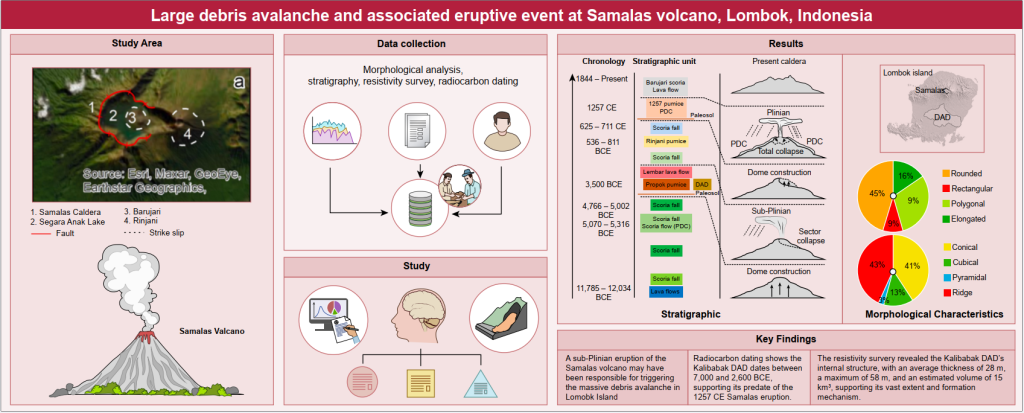
In a remarkable discovery, an international team of scientists have uncovered evidence of a massive volcanic debris avalanche on Lombok Island, Indonesia, that occurred around 3,500 BCE. The study, published in the Bulletin of Volcanology, sheds light on the catastrophic collapse of the Samalas volcano, which produced a debris avalanche deposit (DAD) covering an area of 535 km² with a volume of approximately 15 km³. The research, led by Dr. Mukhamad Ngainul Malawani from Universitas Gadjah Mada, Indonesia, and his collegues utilized a combination of morphological analysis, radiocarbon dating, paleotopographic modeling, and numerical simulations to reconstruct the event. The findings provide new insights into the dynamics of volcanic sector collapses and their potential hazards. Dr. Mukhamad Ngainul Malawani, lead author from Universitas Gadjah Mada, Indonesia said “One of the largest Holocene debris avalanches in the Asian region originating from Samalas volcano (Indonesia) was revealed through morphological reconstruction, avalanche modeling, and radiocarbon dating.“
A Catastrophic Collapse from a Magmatic Eruption
The study identified a hummocky terrain, a key indicator of volcanic debris avalanches, across a vast area in central Lombok. The collapse was likely triggered by a Bezymianny-type magmatic eruption, producing a high-energy, fast-moving avalanche that traveled up to 39 km from the volcano. Unlike purely gravitational collapses, this event was accompanied by a sub-Plinian or Plinian eruption, evidenced by the presence of Propok pumice deposits in the region. Using VolcFlow simulations, the study reconstructed the flow dynamics of the debris avalanche. However, the simulations revealed challenges in accurately matching the modern deposit extent, likely due to changes in pre-collapse topography and complex landscape interactions. Dr. Malawani and his co-workers explain, ” The Kalibabak DAD is a testament to the immense power of volcanic sector collapses. The sheer volume and extent of the deposit highlight the potential hazards associated with such events, not only for the immediate vicinity but also for distant areas that could be affected by the resulting debris flows and tsunamis.“
Reinventing the Past
To reconstruct the pre-collapse topography of the Samalas volcano, the team used the ShapeVolc model, which allowed them to estimate the original height and structure of the volcano. The reconstructed summit of Samalas was found to be approximately 4,207 meters, about 480 meters higher than the current Rinjani volcano, which was formed after the collapse. One of the authors, Audrey Faral adds, “Reconstructing the pre-collapse topography was crucial for understanding the scale of the event. The Samalas volcano was a towering stratovolcano, and its collapse would have been a dramatic and devastating event, reshaping the landscape of Lombok Island.” Furthermore, Dr. Franck Lavigne, the co-author from Université Paris 1 Panthéon-Sorbonne, France said “Understanding the past helps us prepare for the future. The Samalas collapse serves as a reminder of the potential for large-scale volcanic disasters.”
Implications for Volcanic Hazard Assessment
This study has significant implications for volcanic hazard assessment and disaster preparedness. Volcanic collapses like the Samalas event can generate tsunamis, pyroclastic flows, and widespread environmental changes. The findings highlight the importance of monitoring active volcanic systems to anticipate potential collapses that could threaten surrounding communities. Dr. Malawani and his team emphasizes, “Understanding the triggers of volcanic sector collapses is essential for hazard assessment and risk mitigation and the need for continued monitoring and research.”
A Window into the Past
The study and the discovery of the Kalibabak DAD provides valuable insights into the geological history of Lombok Island and the powerful forces that have shaped its landscape. The DAD is overlain by pyroclastic deposits from the famous 1257 CE eruption of Samalas, which is believed to have caused significant global climatic effects. The study suggests that the 1257 CE eruption may have been influenced by the earlier collapse of the volcano and underscores the importance of continued research into volcanic sector collapses and their potential hazards, offering valuable lessons for disaster preparedness and risk mitigation in volcanic regions. Another author from the team, Dr. Lavigne, concludes by saying that “The Kalibabak DAD and the 1257 CE eruption are part of a complex history of volcanic activity on Lombok Island. By studying these events, we can better understand the long-term evolution of volcanic landscapes and the potential for future eruptions.”
Summary
The researchers have revealed evidence of a massive debris avalanche at Samalas volcano on the island of Lombok, Indonesia. The avalanche, known as the Kalibabak DAD, occurred around 3,500 BCE and was likely triggered by a powerful sub-Plinian eruption of Samalas volcano; it significantly altered the landscape and provides new insights into the hazards posed by volcanic sector collapses. The Kalibabak DAD is one of the largest volcanic debris avalanches in the Asian region, covering an area of 535 km2 with an estimated volume of ~15 km3.
The article: “Large debris avalanche and associated eruptive event at Samalas volcano, Lombok, Indonesia,” Published in Bulletin of Volcanology (2024) 86:24 on 2nd March 2024, https://doi.org/10.1007/s00445-024-01727-7
Figure: